Today was a beautiful day in central Virginia, blue sky and gentile breeze, right down the runway. Well it was until I was starting to take off and the wind switched to straight across the runway with gust to 14 knots. All much beyond my abilities. Spring is coming we'll have more nice days soon, and the plane is still in one piece when they come.
Tuesday, February 9, 2021
Thursday, February 4, 2021
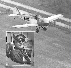
Flew Almost 1 Hour On A Nice February Afternoon
I finally got to tryout the changes I made to the cowl skirt and the position of the cylinder cooling pressure drop probes. I think I may have cut off too much of the skirt. The cylinder head temperature seems to have gone back up about 3 degrees. The oil temperature quickly stabilized at 170 degrees so I'm not overheating the motor.
The shortened cowl skirt allowed good airflow to the venturi, mounted under the fuselage, so the Turn and Bank indicator finally works. I can make nice coordinated 1 needle width turns.
The cabin heat works well enough that I was able to fly without gloves, which was nice.

The first picture is turning from base leg, for runway 23, to the upwind. You can see the airport above the spreader bar. I'm about 1000 feet above the ground.

US 15 is coming out of the left cabane strut. The big new powerlines are just on my left, at the bump on the cowling. Southwest is halfway up the right hand brace wire. It's about 10 miles away.
The small white building between the left cabane struts is the tent the highway department uses for storing rock salt.

 The airport is on my left by the spreader bar. we have lots of trees in Virginia.


OK, I took a selfie with my nice Gryffindor scarf. Hey Harry, I can fly too.
On my right is Merry Mountain and off in the distance are the Blue Ridge Mountains. They do look Blue, don't they?


 I'm now on the crosswind, heading southeast.


Off my right wing is the Town of Gordonsville, they own the airport.
Monday we had about 4" of snow. It's been just cold enough we still have some where the sun can't melt it. The water tower is a good local reference to find the airport. You just about fly over it on a 45 to the downwind for runway 23.
At this point then end of runway 5 is on my left. It's about time to make a left turn to the downwind and land. Nature is calling real loud.
I used about 5 gallons of gas for 0.9 hour of flying.


Subscribe to:
Posts (Atom)