
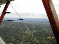
I'm looking down Southwest Mountain, which runs from southwest of Gordonsville to the east side of Charlottesville, about 20 miles long.
Route 33 runs west from Gordonsville around the end of Southwest Mt. The first town west is Barboursville, where route 20 crosses 33.

 In the distance are the Blue Ridge Mountains. Everything around here runs from southwest to northeast. It takes a while to remember the mountains are not north south.


The thin horizontal line above the spreader bar is Charlottesville Airport.

 Today Charlottesville starts along Route 29 for several miles before you reach the city proper.


The city of Charlottesville is the biggest town for about 50-60 miles around.

 I'm going around the southern end of Southwest Mt.


There is some flat open ground that the city is growing into and then the mountain returns as Monticello Mountain and behind it for several miles is Carters Mountain, nice orchard on top.

 Interstate 64 and the Rivanna River run east west through this flat area, past a quarry which seems to be getting much deeper every time I fly over it.

 The arrow points to Mr. Jefferson's home Monticello (Little Mountain).
 The stripe through the trees is for power lines. Interstate highways, power lines and pipe lines have gaps in the trees which make navigating around here much easier, if you use charts instead of GPS.


Heading back northeast, to Gordonsville, on the other side of Southwest Mt.
Still waiting for fall colors.


No comments:
Post a Comment