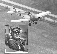
For those who have never flown the Biplane Fly Baby here is what you see out of the side and front. The view is nice but you have more wings and struts in the way than in the Monoplane.
The wire sticking up in the middle is the CUB type fuel gauge. It's not very accurate and occasionally get stuck, but if you don't see much wire find some place to get fuel.
The bumps on the cowl were added to allow shielded ignition wires on the engine when a radio was added.
From April, 1991 thru October 1991 I flew about 140 hours. With the plane based 10 minutes from work I could fly in the morning, evening, and some days at lunch. In the summer my longest flight before work was 1.6 hours. Because the climate is so mild in Virginia I flew every month but December of '90. The coldest day I flew was 15 degrees on the ground. Even with a snowmobile suit I was so cold that after 15 minutes I shook so bad I didn't think I could land. I'm adding cabin heat to help take the edge off. I've read about people learning to fly Curtis Pusher knockoffs from the ice on Lake Fenton in Michigan in the dead of winter. I have no idea how they did it.
If you look over the nose (picture above) you see fog in the distance. The Shennadoah Valley runs down hill to the south, and to the north. The morning fog was still filling the valley south of us on a beautiful morning.
When I turned toward the mountains you can just see the clock, at the bottom of the picture, It's about 6:50 am. I like the smooth air in the morning and evening. In the summer the sun comes up at 5:50 am. We lived about 40 minutes east of the airport near Charlottesville. I would set at the end of the runway waiting for official sunrise to take off.
Most days in the summer are fairly hazy. We've got about 10 miles visibility to the front.
Learning to fly in the flat Midwest, most roads run North/South and East/West. In Virginia roads were built following the high (dry) ground. They are also usually well hidden in tall trees. The easy visual references are the mountains and the cuts through the trees for power lines and pipelines. They usually have about a 100 foot right of way which they keep clear of trees. They're easy to spot and on the charts.
Our oldest son Beau attended the College of William and Mary. In fact he graduated in 1993 the year of the 300th anniversary. In the summer of 1991 he was working on an archaeology dig so I flew over to visit him. This is Jamestown Island, the first permanent settlement in Virginia.
At most airports I can find tie down ropes to use on the tail for starting. The rope is still attached as I get buckled into the cockpit.
A few miles north of Waynesboro is Massanutten Mountain. It runs from here 50 miles north along the middle of the Shenandoah Valley. We'd been there skiing and such before this. From the ground I had no idea that the ski resort is located in the old Caldera. That's right it's a blown out volcano. It must have made a mess when it blew.
I don't think we've been there since this flight.
South of Waynesboro is Wintergreen Resort. It's about 1000 feet higher so they can often make snow when Massanutten can not. They have some longer and steeper runs than Massanutten. It's also pricier. Massanutten is more working class.
Because this area is a pretty tourist destination we have several balloon ride operations. Like me they prefer the calm mornings and evenings. When I can raise them on the radio I'll get a little closer. I have no desire to tangle with a balloon.
On of our tourist attractions is Thomas Jefferson's home Monticello (Italian for Little Mountain). Yes it's pronounced like the musical instrument not that clear stuff you wrap candies with. It is actually on the little mountain. Carter's Mountain behind it is much higher and has a much better view.
It's a little hard to see his house in the summer picture. The garden and vineyard are to the left (east sunlight) in these pictures.
The story is that he had a telescope on his west porch so he could watch the progress on the building of his University of Virginia in Charlottesville. You can see Charlottesville through the wing wires.
The small white building in the Center (below) is the Rotunda at the north end of the Lawn. The Professors homes and class rooms (Pavilions), and the best dorm rooms (East Lawn and West Lawn) are on the east and west side of the lawn. Behind these are the gardens with their Serpentine Walls (it allows walls one brick thick), all hand made by his slaves. Beyond them are more dorm rooms, East Range and West Range. All of it is still used today
One of those beautiful mornings when the moon and sun are both up.
The Shenandoah River winds it's way north to the Potomac river, then south to the Chesapeake Bay. All summer there are canoes on the river.
The mountains are beautiful especially with these long morning shadows. When the wind is blowing allow at least 1000 feet unless you're riding the windward side updrafts in a glider. The down wind side can be terrifying at lower altitudes.
Early morning shadows really highlight how tall things are as well as the topography. The mountains block evening shadows.
We also get some eerie morning fogs to add to the shadows. There are lots of days when the airport is in the clear and the surrounding lower elevations are fogged in. I stay over clear areas where I can make an emergency landing if needed. I've accidentally been in the fog and it is terrifying. Fortunately it was thin and I was able to easily get above it with instruments. The turn and bank will stay in the airplane.
Fall is a beautiful time to fly. The colors are not as bright as New England. You also get unlimited visibility once the trees quit fogging up the air with their misty breath. The Carter's Mountain fire lookout tower can just be seen in the center of the picture.
Nice reflections in the calm waters.
This may look like fall but it's summer. A few warm winters had allowed the Pine Bark Beetle to destroy acres of pine forests. Much of our forest lands are managed for wood pulp. You can see the trees on the left are free of needles. In the middle they are dead and on the right turning yellow and dying. They bore under the bark and kill the trees. A hard winter kills them.
Waiting for those morning fogs to lift.
Sunshine is back, but at the end of October,1991 the oil consumption had reach a point where the engine needed an overhaul. It's one of those good winter projects.


No comments:
Post a Comment